
A route planner that knows gravel from tarmac.
Plan road, gravel, MTB and hiking routes across Europe. Set what you want in plain words, follow the roads other cyclists ride, and get loops of the length you ask for.
Runs in the browser on a computer or a phone. No account needed to plan.
Built for my own rides.
I plan road, gravel and hiking trips and kept missing the same things in other planners. So No Mapa has them: routing by the heatmap, loops, wind and rain, and settings I can read.
Stick to the heatmap
Ride where other cyclists actually ride
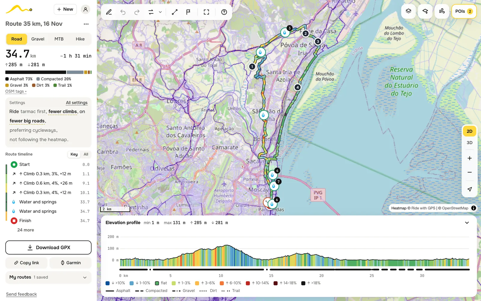
With the heatmap switch on, the planner builds four versions of every leg and keeps the one more people ride, judged by the Ride with GPS global heatmap. On a gravel leg from Loures to Bucelas north of Lisbon, the heatmap score of the chosen way went from 0.55 to 0.88. The same heatmap is a map layer, so you can see what the choice is based on.
How it chooses candidates, scoring, ties
Candidates: the router’s best and second-best leg, and the same two calculated with road class mattering less (every paved road except trunks costs at most 1.6), so a busy but popular road can compete. Versions more than 30% longer than the first are dropped.
Score: the heatmap is read every 30 m along each candidate, taking the brightest spot within about 10 m; yellow means few rides, red many. A point no one rode scores 0, a single trace 0.25, the brightest red 1. The leg’s score is the average. On 9 test legs near Lisbon it went from 0.76 without the switch to 0.86 with it; one leg got slightly worse.
Ties: within 3% of the best counts as equal, because in city centres the heatmap is hot almost everywhere. Among equals, more cycle infrastructure wins, otherwise the shortest.
Road · Gravel · MTB · Hike
Four route types with their own taste in roads
Road bikes stay on tarmac and may take a fast main road. Gravel looks for good dirt and quiet lanes and keeps off busy roads. MTB goes for trails. Hiking follows paths up to the difficulty you choose.
Each kind of road has a price for each type, and the router looks for the cheapest way. So a route never gets stuck: if gravel is the only way through, a road route takes it, though it tries hard to avoid it.
How routing works prices, where the line starts, odd detours
You place points, and every pair of neighbouring points becomes a leg, calculated by BRouter on our own server from OpenStreetMap data. Dragging a point recalculates only the two legs next to it.
The price of a stretch is its length × the price of its kind of way, plus a price for climbing. A price of 1 costs its own length; 3 means the router accepts a detour three times longer to avoid it. Ways closed to you, like motorways, are never used.
| Way | Road | Gravel | Hike |
|---|---|---|---|
| Tertiary road, tarmac | 1.0 | 1.3 | 2.5 |
| Secondary road | 1.1 | 2.2 | 4.0 |
| Primary road | 1.2 | ≈8.6 | 10 |
| Good gravel track | 3–10 | 1.1 | ≈1.0 |
| Cycleway | 1.3 | 1.0–1.3 | 1.1 |
| Steps | 120 | 75+ | 3.0 |
The types are built on BRouter’s own profiles (fastbike, gravel, Poutnik’s MTB and hiking-mountain) with our additions on top. MTB is left out of the table: its prices are on a different scale, where tarmac costs several times a trail.
Where the line starts. A point is matched to the nearest suitable way, so the line may start a few dozen metres from the marker: half of measured leg ends were within 36 m, nine in ten within 154 m.
Odd detours are usually water or a way the type avoids: of 72 test legs, 29 were more than twice the straight distance, 20 of them going round water.
Surface · Climbs · Big roads · Cycleways
Settings you can read as a sentence
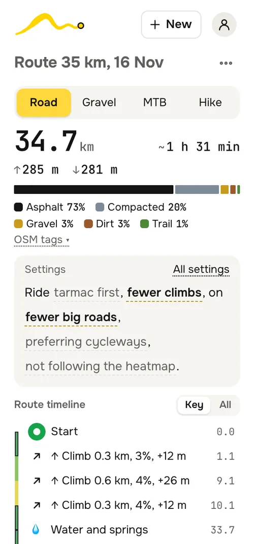
“Ride tarmac first, fewer climbs, on fewer big roads, preferring cycleways.” That line sits on top of every route, and every underlined word is a setting: tap it to change it. “All settings” opens the full list with sliders. Each setting raises or lowers prices by a set factor; the numbers are in the details below.
Only the “May use” boxes are bans: no steps, no ferries, no main roads without a cycle lane, no unpaved, no footpaths.
Every setting, one by one multipliers and test results
Surface, five steps:
| Step | What changes |
|---|---|
| Asphalt only | unpaved ways cost 6 times more |
| Mostly asphalt | unpaved ways cost 2.5 times more |
| Type default | the type’s own taste |
| Mostly dirt | tarmac costs 2.5 times more |
| Trails | tarmac costs 5 times more; the cycleway bonus is off |
Without a surface tag in OpenStreetMap, streets and roads count as paved, tracks and trails as unpaved.
Climbs, five steps:
| Step | What changes |
|---|---|
| Avoid climbs | 100 m of climbing steeper than 1% costs like 30 km of flat; a detour may add at most 40% to the leg |
| Fewer climbs | 100 m of climbing steeper than 1.5% costs like 12 km of flat; at most +20% |
| Usual climbs | the type’s own behaviour: on tarmac none of the four types prices climbing |
| Climbs welcome | climbing costs nothing |
| Seek climbs | of four possible routes, the one that climbs most, if at most 30% longer |
Why the cap: once a road leg grew from 14 to 20 km to save 67 m of climbing. Now every leg is also calculated without the climbing price, and the hill-shy one is used only if it is at most 1.2 (Fewer) or 1.4 (Avoid) times longer.
Steepness limit N%: climbing steeper than N% gets very expensive. Soft: where there is no way round, the steep part stays and the profile marks it.
Big roads (road, gravel, MTB):
| Step | Trunk, primary | Secondary | Tertiary |
|---|---|---|---|
| Avoid | ×4 | ×2.8 | ×1.9 |
| Fewer | ×2 | ×1.6 | ×1.3 |
| Big roads OK | ×0.3 | ×0.58 | ×0.79 |
Where a big road has a cycle lane, the change is halved. On nine test legs, trunk and primary roads made 7% of a road route with Avoid, 16% with Fewer, 52% with Usual and 70% with OK; Avoid made routes about 13% longer.
Cycleways (road, gravel): Ignore; Prefer (default), where ways without cycle infrastructure cost about 2.5 times more for road and 2 times for gravel; Stick to, where only real cycleways, lanes and bicycle streets count and everything else costs about 4 times more. Tuned against the Ride with GPS heatmap: road at ×2.5 kept 94.6% of the route on popular lines with 6.6% extra length.
Avoid cobblestones (road, gravel, MTB; off by default): sett and cobbles cost 4, 2.5 or 1.5 times more. On 40 test segments it cut cobbles from about 2% of the route to under 1%.
Hiking: paths up to T2, T3, T4 or T5–T6 on the SAC scale; signed hiking routes; forest and water; quiet, away from busy roads and towns.
Plan a loop
A round ride of the length you want, from where you are
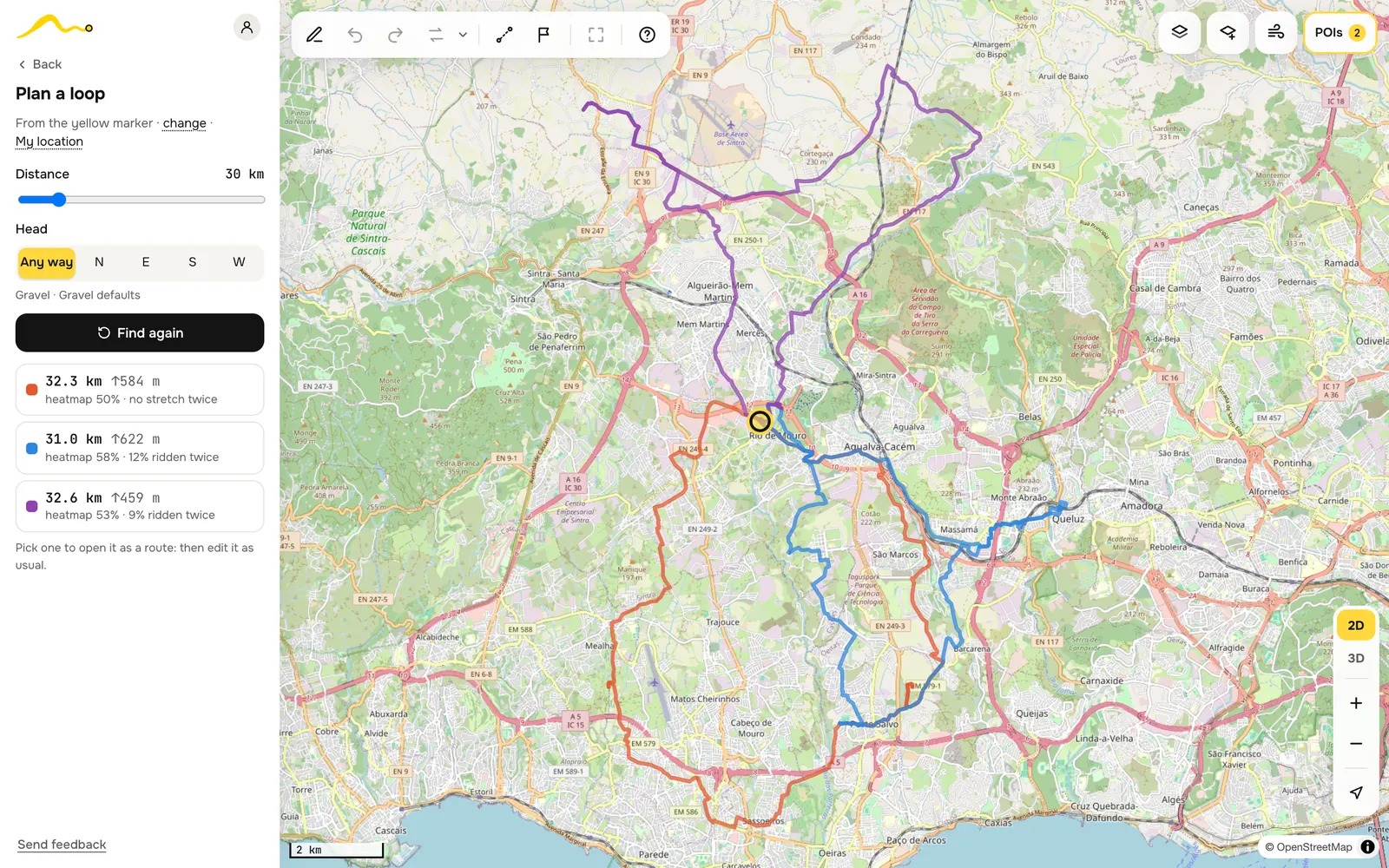
Pick a start, a distance from 10 to 150 km and, if you like, a direction. You get up to three loops, none sharing more than 60% of its way with another, each with its length, climbing, how much of it runs on the heatmap and how much you would ride twice. Pick one and it becomes a normal route you can edit.
How loops are built shapes, resizing, ranking
- A loop is the start plus two or three turning points on a regular shape around it: two up to 40 km, three for longer. With any direction, eight headings are tried, every 45°; with a chosen one, that heading and 30° to each side.
- Roads wind, so the first shape is drawn about 1.3 times smaller than the distance asked. The five closest results are resized by how long they actually came out.
- Loops within 12% of the distance are kept, if there are any.
- Score: heatmap share − 1.2 × share ridden twice − 0.8 × length miss. “Ridden twice” is a stretch that comes back within 25 m of where the loop already went.
- The top three are kept, skipping one that overlaps an already chosen loop by 60% or more.
Wind · Rain · Temperature
Pick the hour, see the weather on your way
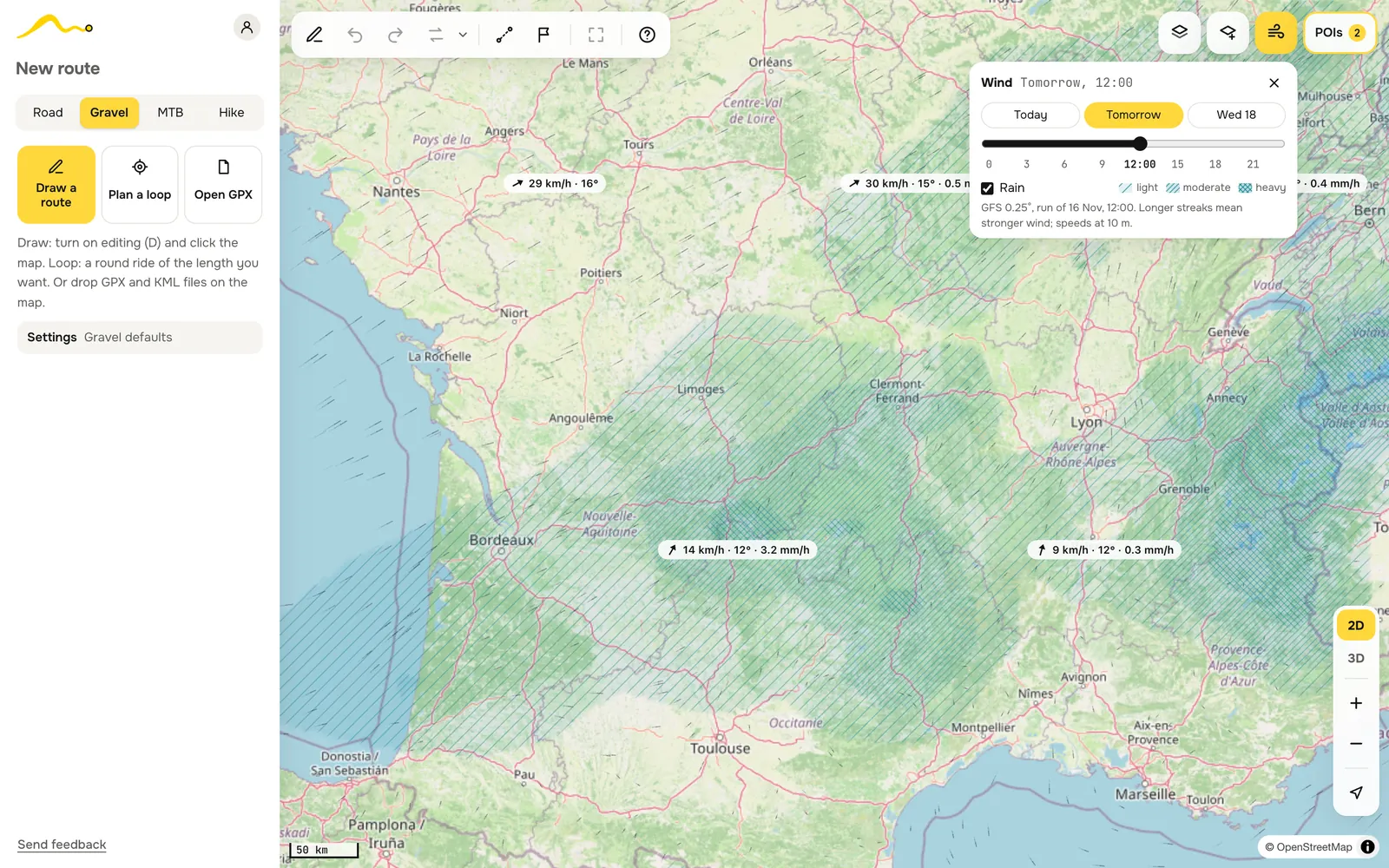
Press W for the forecast of today, tomorrow and the day after, hour by hour. Wind streaks move with the wind and grow longer as it gets stronger. Rain is hatched over the map, denser when it pours. Labels give wind speed, temperature and rain.
About the forecast model, freshness, why three days
NOAA’s GFS model at 0.25°, about 28 km between grid points, blended smoothly between them. A new run comes four times a day and is ready about 4.5 hours later; our server keeps its own copy, so the hour slider needs no outside service.
Rain is drawn from 0.2 mm/h: sparse lines for light rain, twice as many from 1 mm/h, crossed from 3 mm/h. Weaker drizzle is left out because the model spreads it over half a continent.
Only three days because further ahead the forecast is too rough to plan a ride by. Wind does not change the route or the riding time yet.
Along the route · Passes
Water, food, a look at the road ahead, and the passes
Cafés, shops, fuel stations, water taps and springs, beaches, bike repair, sights and viewpoints near the line, with their distance from the start in the route timeline. Street-level photos show what the road looks like before you get there.
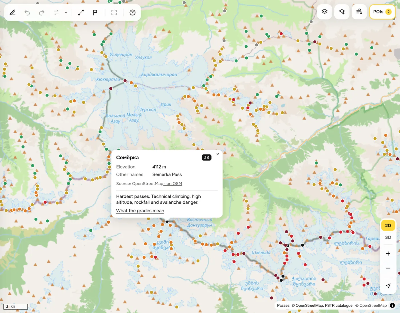
The passes layer puts almost 40,000 mountain passes on the map, coloured by grade. Tap one for its height, other names and what the grade means: here Semerka, 4112 m, graded 3B, the hardest grade there is.
Where it comes from sources and distances
- Places: OpenStreetMap through OpenFreeMap tiles, read by your browser in a corridor of 100 m, 300 m or 1 km around the route.
- Springs: OpenStreetMap springs through Overpass, kept by our server for 30 days.
- Photos within 100 m of the line: Wikimedia Commons, Mapillary and Panoramax, the newest per source every 150 m, each with its date.
- Mountain passes: about 37,000 from OpenStreetMap and about 7,500 from the FSTR classifier, merged, with grades from NC to 3B. See what the grades mean.
Keep · Share · Ride
Your routes on every device and on your watch
Routes save themselves. Sign in, and they follow you to every device. A short link opens your route for anyone, with or without an account.
Download a GPX with checkpoints as waypoints, or send the route straight to a Garmin watch. Open a GPX or KML file and turn a recorded track into a route you can edit.
Send to Garmin is an unofficial beta through the same sign-in as the Garmin Connect app; GPX always works. How it works and what it can access.
Questions
- Do I need an account?
- No. Planning works without one, and routes are kept in your browser. An account adds sync between devices and sending to Garmin.
- Where does routing work?
- Across Europe with the Azores, Madeira, the Canaries and Iceland, and Russia. The weather covers Europe and European Russia up to the Urals.
- How fresh is the map?
- Roads, trails and surfaces come from OpenStreetMap; our router takes updates weekly. A trail added to OpenStreetMap today shows up after the next update.
- Why does my route take a detour?
- Usually water, or a road your route type avoids. Open the leg’s surface details, change a setting, or draw that leg straight if a trail is missing from the map.
- Does it work on a phone?
- Yes, in any modern browser. The panel becomes a sheet you pull up from the bottom.
- What do you do with my data?
- Keep the routes you save so you can open them anywhere. Your data is not sold or shared. Analytics never sees coordinates or route names. Account and data.
Where the data comes from
| What | Source | How fresh |
|---|---|---|
| Roads, trails, surfaces | OpenStreetMap, routed by BRouter on our server | weekly updates |
| Elevation | BRouter’s routing data; AWS terrain tiles (about 30 m) for straight legs and imported tracks | static |
| Heatmap | Ride with GPS global heatmap | live tiles |
| Base maps | OpenStreetMap, CyclOSM, OpenTopoMap, mapy.com, Google, Bing, Yandex, Esri | each provider’s own |
| Places and springs | OpenStreetMap via OpenFreeMap and Overpass | OpenFreeMap’s own; springs kept 30 days |
| Photos | Wikimedia Commons, Mapillary, Panoramax | date shown on each |
| Wind, rain, temperature | NOAA GFS 0.25° | four runs a day |
Thanks. No Mapa began as a rebuild of nakarte.me by Sergey Orlov, and its routing runs on BRouter by Arndt Brenschede, with route profiles by quaelnix (gravel) and Poutnik (MTB and hiking). A lot has changed since, but this is where it started.
Routes are suggestions: OpenStreetMap can be wrong or out of date. Check closures, access signs and conditions on the spot. Found something wrong? “Send feedback” is at the bottom of the planner’s panel.
Plan your next ride.
Open the plannerNo account needed. Your routes stay in this browser until you sign in.